|
 |
||||||||
|
"RETURN
TO NEGROS"
|
At
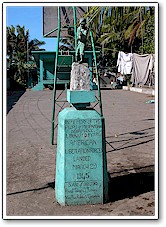
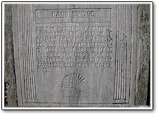
Pulupandan I carried with me photos of Green Beach from my I then travelled by bus north to Bago Bridge. The bridge used by the 503d was damaged in a typhoon in 1991 and has been replaced. Some piers are still visible. There are commemorative markers at both approaches to the old bridge, one marker placed in 1990 and the other in 1995. |
||||||||
|
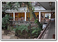
The only site I visited in Bocolod was the Sea Breeze Hotel. The 503d used it as a hospital during the war. General Kona was taken there when he collapsed following his surrender ceremony, August 30, 1945, near Hacienda Santa Rosa, about seven miles east of Murcia. I wanted to stay one night at the Sea Breeze, but it was fully occupied because of a medical convention.
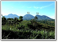
In Silay I was escorted by the city�s Tourism and Culture Director, Ver Pacente, whose office is in City Hall. He gave me a walking tour of Silay including two old sugar baron mansions and the San Diego Pro-Cathedral. The only building in Silay relevant to the 503d is the Gamboa house which was used by Colonel Jones as a command post. It is still intact, but is a private residence within a walled compound. I was able to see it by entering the courtyard of the St Tereseita Academy, a girls school that shares a common wall with the Gamboa house compound. Mr. Pacente showed me some other school buildings in Silay that were used by the Japanese as barracks during their occupation. On my January trip I did not have sufficient knowledge to follow the 503d trail in the mountains. I expected to find maps and literature in Silay regarding the battle, similar to what you find at Civil War battlefields, but nothing is available. I did visit some Japanese shrines, about three miles north of the area of most intense combat for the 503d. Mr. Vacente showed me several Japanese caves in the vicinity of the shrines. Weather was perfect in January and I took some clear pictures of the battlefield from the shrine area.
|
|||||||||

 I visited Negros
Island in January and September 2004 to trace the route of the 503d from the
landing at Pulupandan on April 7, 1945, over the Bago Bridge, through Bacolod,
to Silay and Hacienda Hinacayan, before beginning the assault on April 9 into
the Patag mountain range.
I visited Negros
Island in January and September 2004 to trace the route of the 503d from the
landing at Pulupandan on April 7, 1945, over the Bago Bridge, through Bacolod,
to Silay and Hacienda Hinacayan, before beginning the assault on April 9 into
the Patag mountain range.